


Over 200 volunteers with the Butte County Office of Education made the yearly event happen for nearly 700 students.
- Storm Tracker Weather
- Forecast
- Action News Now:
- Download Our Apps
- Sign Up For Email Alerts


It's a good idea to throw on a light extra layer & to grab your sunglasses before you head out the door Friday, but you'll want to dig out…


Action News Now Features


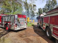
The fire is in the area of East Avenue and Aitken Road, east of Corning.


Chico firefighters were able to help treat the person and fight the fire simultaneously.


It is unknown at this time what exactly sparked the fire, the Chico Fire Department said.